Olcott Falls Canal

Carey Atlas of 1795

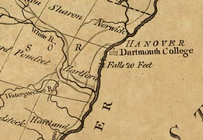
The Olcott Falls Canal is in Lebanon New Hampshire. It is found in the small village of West Lebanon. It is opposite the village of White River Junction which is in Hartford Vermont. It is the 6th of the six navigational canals of the Connecticut River that you meet as you go from south to north on the river. It is the 5th one of the six built. It was completed in 1810 and lasted until the 1850s. It is only a few feet in length and had five locks to lift it 40 feet. This canal is located about 2 to 3 miles north of White River Junction of Vermont.

On October 21 1795 Vermont granted permission for the canal. On June 12 1807 New Hampshire granted permission for the canal. It bypasses the Olcott Falls by using the New Hampshire side of the river. Mills Olcott completed the canal with locks in 1810. It was profitable the first years. When the railroad was built along the river, the canal fell into disuse.

Once a boat is past this falls, then they could approach the base of the Fifteen Mile Falls. This Fifteen Miles Falls was never canalized since the falls is 20 miles long and has a drop of about 180 feet in height. This long falls is in Barnet Vermont. Boats could now navigate the Connecticut River from Hartford Connecticut to Barnet – 220 miles above Hartford.

There are wonderful stories of a ship called the Barnet out there. A company called Brown and Bell were the builders of the Barnet. The ship was made to skirt the river through these canals. It was made but its maiden voyage had to made shortened.

Sumner Falls Canal

The Sumner Falls Canal in Hartland Vermont is the 4th of the six navigational canals of the Connecticut River that you meet as you go from south to north on the river. The Sumner Falls Canal is between Hartland and North Hartland Vermont and 7 miles south of White River Junction. It is the 4th one of the six built. It was completed between 1803 to 1809 and lasted until 1856. It is only a few feet in length and had but two locks to lift it 12 feet.

The Ottauquechee River is to the north of the Sumner Falls Canal. The Water Quechee Falls is just three miles south of the tributary river and that is were the canal is.

October 22 1794 Vermont grants approval for the canal and then on December 1796 New Hampshire grants approval for the canal. Perez Gallup was the first owner and his Vermont land was alongside the canal. It had several owners through the years with the last being David Sumner. The locks and a saw mill were carried away in 1856 and never rebuilt. Remnants of the locks are still in place.

Watch a video from  Jay Boeri about the Sumner Falls Canal – external LINK.

Bellows Falls Canal

The Bellows Falls Canal in Vermont is the 4th of the six navigational canals of the Connecticut River that you meet as you go from south to north on the river. It is the 3rd one of the six built. It was completed in August 1802 and lasted until 1858. It is a half mile in length and had nine locks to lift it 52 feet. Its cross section was 22 feet by 4 feet but is now 75 feet by 17 feet. That is since in 1866 it was turned into a power canal that was wider and deeper.

1907 view of the canal

The Atkinson Brothers of London England came with money and will power to build this canal. The canal was commissioned in 1791 and was the first commissioned canal in the USA.

During the construction of the canal one mill was already in place to use the canal as a power canal also. At least one mill of the many that came later still exists – the Frank Adams Grist Mill.

EXTERNAL LINK to a fine video about the falls.

History of the Town of Rockingham Vermont

Sanborn map analysis:

Sanborn 1885 map

Sanborn 1891 map

Sanborn 1896 map A and map B

Sanborn 1901 map A and map B

Sanborn 1906 map Amap Bmap C

Turners Falls Canal

The Turners Falls Canal in Montague Massachusetts is the third of the six navigational canals of the Connecticut River that you meet as you go from south to north on the river. It is the 2nd one of the six built. It was completed in 1798 and lasted until 1856. It is 3 miles in length and had ten locks to lift it 55 feet. It was 14 feet wide. Oxen trails were used to tow boats.

Christopher Colles started a survey of the canal on July 3 1792. He had surveyed the South Hadley Canal on May 21 a few months before. Benjamin Prescott of Northampton was the designer of both canal systems and that is why the South Hadley and Montague Canals had much in common. (The charter for the canal in Montague had been granted on February 23 1792.) In 1794 Captain Elisha Mack had built the crib dam across the river to force water into the canal. Through out the canal basin there had to be spots along the way that had small ponds built to allow the ships to pass. The Montague Canal took a lot longer to build than the South Hadley Falls Canal did and this might have been due to either there was more dirt and rock to move or to financing. There are two points along the former canal bed where the canal remnants are visible – one at the Shanahan Construction Company and another at the Moore Golf Course.

In 1864 the canal started being used as a power canal with hydromechanical turbines. This was under the guidance of Alvah Crocker. From June 9 1886 onward, hydroelectrical turbines would start. Many mills would use this power canal – John Russell Cutlery, and more. Residential areas would develop too – the Patch, and more.

The Turners Falls Power Canal has taken over most of its length since 1904 when construction began on the new power canal system. Construction ended in 1929. There are two dams – the Montague Dam and the Gill Dam. There is one gatehouse – the Turners Falls Gatehouse (1903 to 1904). There are seven bridges over the canal – 2 are footbridges and 2 are railroad bridges. Turners Falls Power Station number 1 was constructed from 1904 to 1906. The dimensions are 2.7 miles long, 125 feet wide, and about 15 feet deep. Turners Falls Power Station number 2 was constructed from 1912 to 1916 and would be capable of generating 48 MW.

The Canalside Rail Trail (EXTERNAL LINK) is now alongside the canal.

Sanborn map analysis:

Sanborn 1884 map

Enfield Falls Canal

The Enfield Falls Canal in Windsor Locks Connecticut is the first in geographical order of the six navigational canals of the Connecticut River that you meet as you go from south to north on the river. It is however the last one of the six built. It was started in June of 1827. It was completed in November 1829 and lasted until the 1970s. It is 5.25 miles in length and had four locks to lift it 30 feet. It was 70 feet wide and thus large ships could pass through. The Connecticut River Banking Company (Hartford) was founded in 1825 in order to finance the canal.

A power canal would replace the navigational canal and would have many mills between it and the Connecticut River. The New York, New Haven, and Hartford Railroad would also pass through being just to the west of the canal. When the bike path was put in it would NOT pass over these rail lines. It would rather be placed over the former tow path. TRAIL MAP of the bike path.

Sanborn map 1885 map Amap B

Sanborn map 1892 map A map B

Sanborn map 1897 map Amap B

Sanborn map 1905 map Amap B

Sanborn map 1912 map Amap Bmap C

Navigational Canals of the Connecticut River

My modifications on a US Fish and Wildlife Service map.

1793 map of Vermont

1794 map of Vermont

1817 map of Vermont

The navigational canals of the Connecticut River were made to allow transport of goods from Long Island Sound to upper Vermont without portage. At the end of the canal days, one could go from Old Saybrook Connecticut to the Wells River in Vermont 280 miles upstream. This was a difference in elevation of 500 feet.

LINK to my Patreon pay per view video on this topic.

canalLINKlocationstartsendslengthfalls (feet)locks
1Enfield Falls CanalLINKWindsor Locks Connecticut18291970s5.25 miles304
0Willimansett Falls CanalLINKChicopee
Massachusetts
17961.0 mile2
2South Hadley Falls CanalLINKSouth Hadley Massachusetts179418622.5 miles5810
3Turners Falls CanalLINKMontague Massachusetts179818563.0 miles5510
4Bellows Falls CanalLINKRockingham Vermont180218580.5 miles529
5Sumner Falls CanalLINKbetween North Hartland and Hartland Vermont1803 to 18061856feet122
6Olcott Falls CanalLINKWilder Vermont and New Hampshire1810feet405

Farmington Canal – external VIDEO

Farmington Canal – 1840 map

William Skinner

The Skinner house at 1155 Northampton Street is hard to see from the road. This was built in the French Provincial style. The front lawn is visible from Northampton Street. There were two ponds on the property and they were each changed into a reservoir.

William Skinner had this home made for his family. The landscape was designed by Olmsted Brothers from 1917 to 1922. The estate itself is called the Dogwood.

This image has an empty alt attribute; its file name is sheets_0003-1024x896.jpg

Holyoke Municipal Milk Station

3000 quarts of milk were used in the city in 1891. There were 491 cows in Holyoke in 1888. That gives one the scope of the quantity of milk that needed to be looked into. Milk is very important for the development of infants. However the purity is always in question due to the retailers that water down the milk or use spoiled milk. One method the city used was to test the specific gravity of the milk. Specific gravity is the ratio of the density of a liquid compared to water. The city would test the specific gravity with a lactometer. Since the specific gravity of milk is 1.03, milk should settle lower than milk. Along with other tests such as chemical tests, the milk can be analyzed.

This Milk Station was at the southwest corner of South Bridge and Sargeant Streets (34 to 36 Sargeant Street). Holyoke Infant Hygiene Association started on June 1 1911 to help mothers get pure milk for their infants. The first distribution was on September 1 1912. This was the location for only a year since it moved to 40 Sargeant Street.

The Holyoke Municipal Milk Station was later part of the Child Welfare Commission. This Child Welfare Commission was one of the departments of the City of Holyoke. It started on May 20 1919. This Child Welfare Commission was started by Minnie Ryan Dwight (1873-1957).

From October of 1923 it was located at 17 Spring Street and there it was called the Municipal Child Health Center and Milk Station. Luella Thomson is the nurse in charge. The milk is still distributed from a 34 Sargeant Street location for a short time.

The annual Holyoke City Report mentions the Milk Station in 1928 but not in 1929 so it might have been fully integrated into the Child Welfare Department in that year. All reports from 1930 onwards do have the Milk Station in the Child Welfare Department. In 1934 the Milk Station Laboratory and Center were terminated for good. One reason was a positive reason and the other negative. The increase in home instruction had led to mothers’ being independent but on the other hand the worldwide depression had caused a lack of money. [The Milk Station Laboratory was where milk formulae were made.]

The picture is from the 1937 paper and shows the Milk Station. It must have been turned into a dental clinic.

Look at this decrease in infant deaths per 1000.

1910150
1915100
192090
192570
193050
193540
194030
194522
195012

Sadie Leion was the first nurse and social worker at the milk station.

Laura Antz Whitten was one of the driving forces.

There were many substations of the milk station around Holyoke:

  • Hebert Drug (Ely)
  • Rigali Fruit (Lyman)
  • Demenei Fruit (Sargeant)
  • Martin’s (Hampden)
  • Schmitter Drug (South Street)
  • Ridgewood Pharmacy (Northampton Street)
  • Mielke Filling Station (Main)
  • Curran Brothers (Main)

Most very large city across the United States had milk stations in the 1910s. Read about the New York City one HERE in a complete analysis. It seems to have been started as a private charity venture by the owner of Macy’s.

LINKS

Nathan Straus

Nursing Babies

Milk Stations and Public Health

Schools of Holyoke

Lovering School

The Schools of Holyoke are numerous through history.

schooladdressyearendsnotes
North Chestnut Street SchoolLINK1852contains high school 1852 to 1862
Lyman Street SchoolLINK18621901
Elm Street SchoolLINK1862high school was there but moved in 1898
Carlton Street SchoolLINK1865
Ewingville SchoolLINK18651921
West Holyoke SchoolLINK1867
Appleton Street SchoolLINK1867
Park Street SchoolLINK1868
Sargeant Street SchoolLINK1869
East Dwight Street SchoolLINK1880
Nonotuck Street SchoolLINK1883
South Chestnut Street SchoolLINK1885
Hamilton Street SchoolLINKMay 1887
Elmwood Street SchoolLINK1887
Bridge Street SchoolLINK18941907
West Street SchoolLINK1896now Kelly School
Back Street SchoolLINKserves Ashley
Ingleside SchoolLINK
Highland Grammar SchoolLINK19001980s
Morgan SchoolLINKstill
Kirtland SchoolLINK
Maurice Donahue SchoolLINKstill
Lynch SchoolLINK
Sullivan SchoolLINKstill
McMahon SchoolLINKstill
Holyoke High SchoolLINKstill
Peck SchoolLINKstill
LawrenceLINKstill
WhiteLINKstill