The Saint Jerome Church (Campus and Neighborhood) walking tour booklet is available from me. They cost $5 for a black-and-white stapled copy. Each additional copy after that is $3 more when shipped together. For a color copy, the cost is $8 and each additional copy in color is $6.
Email me from my contact page for details. The booklets that you order will be mailed to you via USPS so I need a physical address. Other booklets are available at the BOOKLET page.
Powers Paper Mill existed from at least 1890 to 1905 near the railroad of the Third Level Canal. They made Connecticut Valley Mills paper and also Brunswick Extra Fine Paper.
Sanborn 1895 map – there are located inside the Connecticut River Paper Company and before that they are hard to find
First Baptist Church including its Elmwood Neighborhood
Private GROUP TOUR (COSTS) is one hour long for this First Baptist Church (Campus and Neighborhood) walking tour. It is fully outdoors. Also a one hour indoor presentation can be given.
A free public tour comes up every five years.
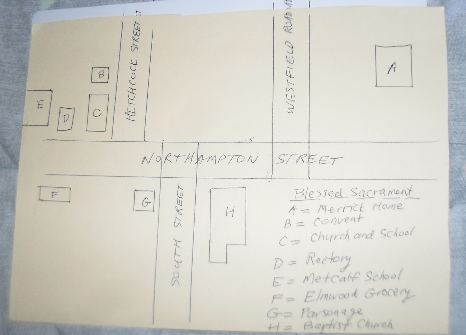
A self-tour is available for anyone using the maps and text seen below. – LOCATION
stop A – Elmwood Neighborhood
Messier Funeral Home
There are also many important homes in the Elmwood area. One is the Prosper Hitchcock home one house south of the SW corner of Westfield Road and Northampton Street. The home was then owned by his son Dexter Hitchcock who became a state senator. Another is the Lawson Long home just south of the Blessed Sacrament rectory along Northampton Street. The home is the oldest home left in Elmwood and is from the 1820s. He and his son also named Lawson were the preeminent physicians in Holyoke.
Messier Funeral Home is the former home of Donald MacKintosh. His family lived here from 1875 to 1945. His mills made men’s suits.
Across the street from the Metcalf School is a store-based building. In the 1940 it housed the Elmwood Drug and Elmwood Market. There was also a flower shop. In the 1920s it houses a candy shop and a grocer.
The Elmwood section of Holyoke is the oldest section of the city. Still as far as Catholics are concerned it could be called the youngest.
Elmwood Park used to be its northern and eastern border but the park is gone.
stop B – Baptist Church Parsonage
In 1879 the parsonage was moved and the Baptist Church was torn down.
By 1880 there was a new brick faced Baptist Church and a new parsonage across South Street. These would serve the congregation well. The church is still there. (The church was enlarged in 1906 and you can still make out that work.
A third parsonage was built behind the church on the same side of South Street. No good church would be complete without a school and the same with the Baptists. It first minister organized the Rand Seminary on Homestead Avenue along his own home. In 1846 the academy was moved to the NW corner of Northampton Road and Westfield Road where the Blessed Sacrament Parish would be. It was disbanded in 1872. (It has also been called Gamwell Academy.)
stop C – First Baptist Church of Holyoke
The first religious buildings and the first religious organizations of Holyoke were in the Elmwood section of Holyoke. The Third Parish of Springfield was the northern parish and this would become Holyoke in 1848. This area needed a meeting house for its religious needs. This was built in 1792 at the corner of Gilmore Street and Northampton Road.
Both the Baptists and the Congregationalists used the building together. In 1799 the Congregationalists started their formal organization. In 1803 the Baptists started theirs under the name Second Baptist Church of West Springfield. In 1811 the meeting house was moved to where the Metcalf School is now and was also finished off inside with pews.
Finally, in 1826 the First Baptist Church built a wooden church of their own at the corner where it is now located. The following year the Baptist parsonage was built at the SE corner of the same location. The Congregationalists would also eventually leave the Meeting House in 1836 moving to the village of Ireland Parish.
stop D – Elmwood Cemetery
It lies along the old Elmwood Cemetery. Its former names were Third Parish Burial Ground and Baptist Village Cemetery. Its first burials were in 1755 which might be the year that it started since there were only a few settlers in the area by then.
Use this Holyoke Heritage Trail tour booklet to follow the route that I have designed to honor the heritage of Holyoke. If you prefer, you can follow the TOUR on the internet.
Booklets are available for a self-guided tour of the Holyoke Heritage Trail. They cost $8 for a black-and-white stapled copy. Each additional copy after that is $5 more when shipped together. For a color copy, the cost is $13 and each additional copy in color is $10. Both booklets are folded letter-sized sheets with 40 pages.
Email me from my contact page for details. The booklets that you order will be mailed to you via USPS so I need a physical address. Other booklets are available at the BOOKLET page.
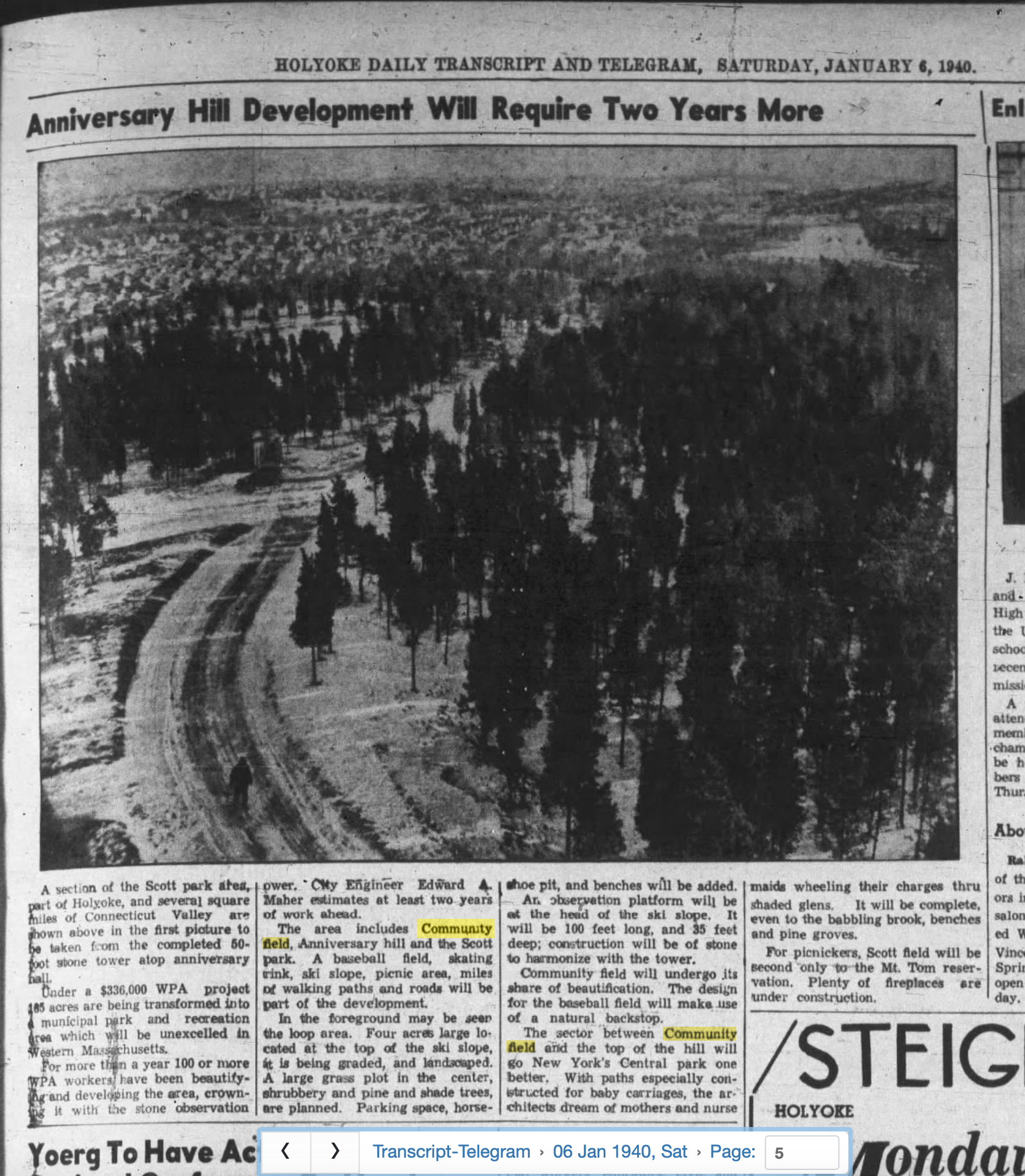
Anniversary and Community Fields are joined parks within Holyoke that were built up during the 1920s and 1930s. Anniversary Hill Park was made in Holyoke for the 50th anniversary of the city of Holyoke. This was in 1923 and it was made from the joined lands of Crafts Hill and the Scott land. The field runs from Northampton Street up to the top of Crafts Hill. The top portion borders against Community Field.
To celebrate the opening of the hilltop as a park, a pageant was held here in 1923. NEWSPAPER article.
Also a topographical survey was done in 1925 of the park and hill and this map is with the Parks Department.
Nowadays Easthampton Road and the Interstate 91 both cross Anniversary Hill. Once upon a time only Easthampton Road would come down the Anniversary Hill. Since the hill was a cleared area due to its being a farmed area, people could ski on the hill.
Anniversary Field
Drum corps team from around New England would use Anniversary Field in its earliest days to have contests. Cows would wander up and down the hill and graze on the grass giving the Anniversary lawn a fresh look. Really cool to know were the staged battles on the hill.
In 1929 Anniversary Field (at the Northampton Street base of the park) received a radical make over into a recreational area. A baseball field, a football field, a basketball court, a bowling green, and a horseshoe court were added. Anniversary Field was dedicated Labor Day 1935. There have many musical bands that played here through the years including this August 30th 1937 nine band concert. This was from the Eastern States Band Association.
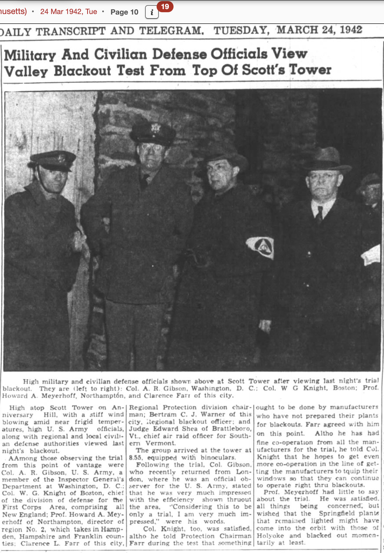
The Civilian Conservation Corps (CCC) worked on the area on the top also and made many trails. In that year there was a clearing and grubbing of all the hill form a WPA project. In 1942 an archery range and in 1941 a football field were added to Anniversary Field. In that year also a group called the Committee on Public Safety would use Scott Tower as a plane spotter location. In 1943 the Signal Corp soldiers used the tower as a signal and observation lookout. In 1948 a new ice rink was placed into Anniversary Field and a new roadway was added to Community Field.
Crafts Tavern and the Lynch School
At the base of the hill was Crafts Tavern. This was a very old building that had served Holyoke well since its beginning. In 1950 the Lynch Junior High School would replace it. (Lynch was completed in 1952.) Holyoke tried to sell the tavern but there were no takers since the building would have to be moved. In 1958 a new softball field is added.
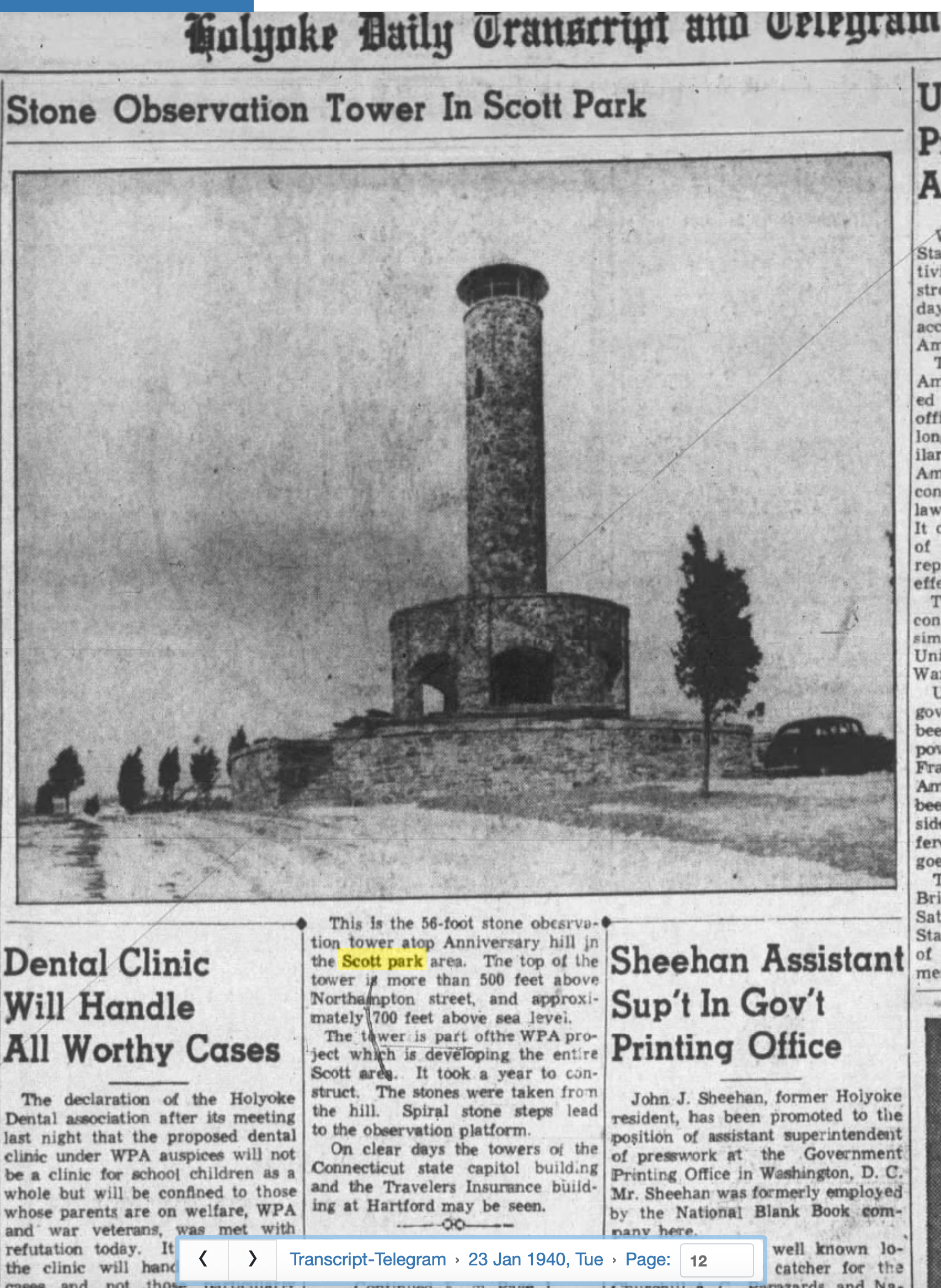
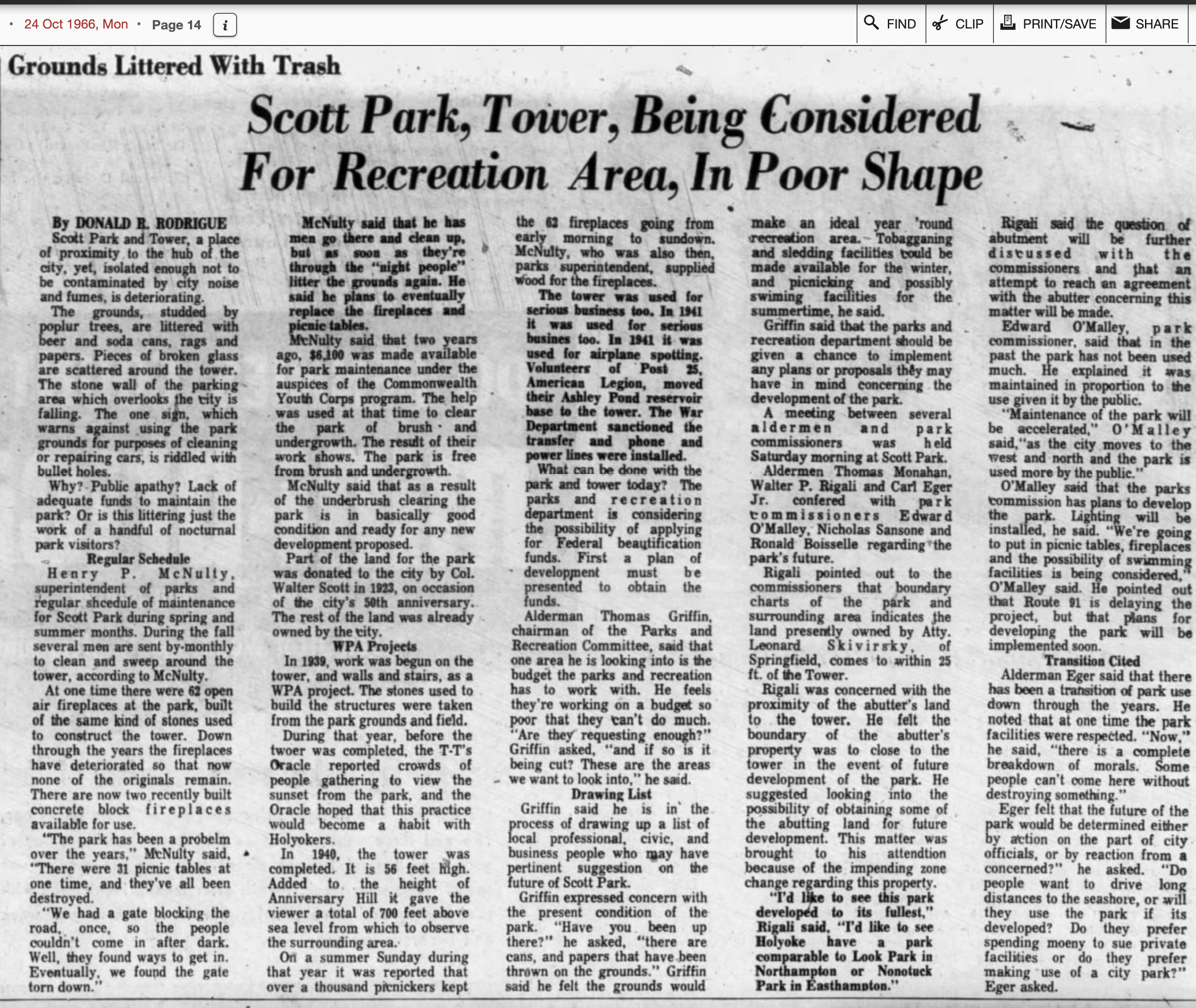
Scotts Tower
In 1939 a new tower was built here and called Walter Scott Memorial Tower. It was dedicated on December 24th of that year. It was named after Walter Scott (FINDAGRAVE) the donor of this land. During its first year it had thousands of visitors. The base was star shaped and the tower had 68 steps.
On its grounds, were added 32 fireplaces and 22 picnic tables.
In 1936 Anniversary Hill Park had had its summit name changed to Walter Scott Field. There must have been a plaque placed by Jarvis Avenue since in 1943 the city registry reports that it was moved to easterly side of the tower.
In 1941 a cabin was constructed at the entrance to the Scott Memorial Tower. In 1955 a paved lookout is added to the east of the tower and trees removed from that area. In 1956 a parking lot was added just to the south of the tower along with some more trails.
In 1976 using Legacy of Parks federal funds, the picnic tables were replaced and the stone bridge repaired. Most importantly, Scotts Tower was given a facelift.
Bowling on the Green
Floodlights were added to Bowling on a Green in the 1940s. The Holyoke Bowling Club would be started at some point. It was decided in 1954 that the Anniversary Field Bowling Green would no longer host major state and New England tournaments as it once did. However, from July 29 to August 3 of 1962, the New England Lawn Bowling Association Tournament was held here. In 1967 there was heavy damage from rainstorms into Green area (this was due to the slopes below the new interstate being not drained well).
Tennis Courts
Tennis courts just above the baseball field was added in the 1930s.
Skiing in Anniversary Field
Beginning in 1937 the top of the hill was developed into a ski area. In 1938 skiing officially commenced on the slope of Anniversary Hill. This would become known as Ski Run. This was the first city owned ski run in Western Massachusetts. The smaller slopes on the northerly side were used by younger people.
A downhill run of from 1000 feet to 400 yards was possible from the top of Anniversary Hill Park to the bottom in the Bowling Green area of Anniversary Field. Easthampton Road was off to the side until the mid-1960s so it was a clear run. The ski lift was a old car’s axle that had a chain running around it and then had a long rope attached to that. In 1940 during construction of the ski run, an observation platform was added at the top of the hill. It was 100 feet long and 35 feet deep and was of stone construction. A 1952 statement in the city register states that activity is declining at the ski slope but that small slopes on the north face of the hill were being used by youngsters for sledding and skiing.
At some point of time between 1915 and 1946 the Dwight Street Extension was put in.
Dillon Avenue is to the right of the ski run in the image.
Other Activities
Toboggan and Sledding
A toboggan slide was made in 1952 but it had been planned long before that.
Interstate 91
From 1963 to 1965, Interstate 91 would be constructed through both Anniversary Field and Community Field. It cut both into two parts of their own. Since they were contiguous parklands, one could know say that there were 3 parklands – Anniversary Field, Community Field, and Anniversary-Community Hill. The interstate would take 40 acres in total from the parklands.
There had been talk of a new pool on top of the hill. In 1966 Holyoke was going to pay for it themselves but the government knew that the state had a fund that helped Western Massachusetts communities build rinks and pools. An article in the Holyoke Transcript states that the ward one pool was made in 1911, the wards four and six pools both in 1925, and ward two pool in 1926. In 1967, a new pool funded by the state was started at Anniversary Field (it would be ready on June 16 1969). This would be called Chmura Pool. It was located at the very top of Crafts Hill. It was built within the oval loop of the road just below the tower. About the year 1991, the Chmura Pool would close for good having been open only 22 years. The state was in charge of its care and it was hard to care for a pool at the top of a hill.