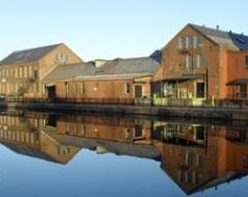
The Turners Falls Canal in Montague Massachusetts is the third of the six navigational canals of the Connecticut River that you meet as you go from south to north on the river. It is the 2nd one of the six built. It was completed in 1798 and lasted until 1856. It is 3 miles in length and had ten locks to lift it 55 feet. It was 14 feet wide.

Christopher Colles started a survey of the canal on July 3 1792. He had surveyed the South Hadley Canal on May 21 a few months before. Benjamin Prescott of Northampton was the designer.
In 1864 the canal started being used as a power canal with hydromechanical turbines. This was under the guidance of Alvah Crocker. From June 9 1886 onward, hydroelectrical turbines would start. Many mills would use this power canal – John Russell Cutlery, and more. Residential areas would develop too – the Patch, and more.
The Turners Falls Power Canal has taken over most of its length since 1904 when construction began on the new power canal system. Construction ended in 1929. There are two dams – the Montague Dam and the Gill Dam. There is one gatehouse – the Turners Falls Gatehouse (1903 to 1904). There are seven bridges over the canal – 2 are footbridges and 2 are railroad bridges. Turners Falls Power Station number 1 was constructed from 1904 to 1906. The dimensions are 2.7 miles long, 125 feet wide, and about 15 feet deep. Turners Falls Power Station number 2 was constructed from 1912 to 1916 and would be capable of generating 48 MW.

The Canalside Rail Trail (EXTERNAL LINK) is now alongside the canal.

Sanborn map analysis:
