
The Proulx Block is at 344-346 High Street.
Sanborn map analysis:
Sanborn 1884 map is a 4 floor block with a harness shop and apartments above it
The Proulx Block is at 344-346 High Street.
Sanborn map analysis:
Sanborn 1884 map is a 4 floor block with a harness shop and apartments above it

Fenton and Dunn
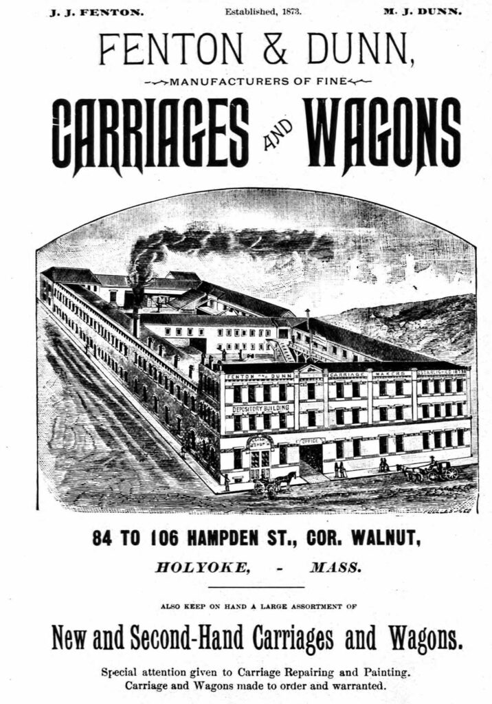
The carriage at Wistariahurst is a Fenton and Dunn one. LINK
Run by JJ Fenton and MJ Dunn. HISTORY
The Wagner Spring Bed Manufacturers move into this location. Carriages and wagons are not as useful in the automobile.
At some point it turns into a furniture warehouse site.
Sanborn map analysis:
Sanborn 1884 map – building is small compared to what it would become with blacksmith, paint room, lumber yard, and more
Sanborn 1889 map – has been built up with brick facade on half the structure, more lumber storage
Sanborn 1895 map – more wagon sheds have been added across the street
Sanborn 1915 map – now Wagner Spring Bed Manufacturers
Sanborn 1949 map – furniture warehouse
Sanborn 1956 map – furniture warehouse

Willard lumber, planing, and moulding mill. Coughlan in same building.
Coghlan’s Holyoke Steam Boiler and Iron Works was started by D F Coghlan. They made iron and steel steam boilers and also rotary bleachers and penstocks.
Thomas Sears was the superintendent. FINDAGRAVE


Sanborn map analysis:
Sanborn 1915 map – not there


The Bud was at 30 John Street. No, there was never a tunnel from Holyoke City Hall to the Bud. Perhaps city officials would love to have such a tunnel to got to their favorite pub but no evidence is there.
Sanborn map analysis:
Sanborn 1884 map shows that it is a bottler of alcohol and that is wooden and 2 floors
Sanborn 1889 map same
Sanborn 1895 map shows it as a candy factory and it is 3 floors and brick
Sanborn 1915 map it is now for wholesale alcohol
Sanborn 1956 map shows that it is a restaurant
The Besse System Building is an old structure even though the facade is new. It is at 292-300 High Street. The alley side of the building once had a stained glass window.
Lyman Besse started up a chain of stores across the northeastern USA. He lived in the McKnight neighborhood of Springfield. See his FINDAGRAVE page. See one of his ads.

In 1918 it is being called the Besse Mills Company.
Sanborn map analysis:
Sanborn 1884 map shows an empty lot
Sanborn 1889 map shows three 1 story buildings on that lot
Sanborn 1895 map shows one 1 story building only
Sanborn 1915 map shows a three floor building there
Sanborn 1949 map shows the same
Sanborn 1956 map shows the same
In the beginning this is called the Ducharme Building. It is at 309-311 High Street. By 1940 it is called the Buckingham Block.
Its present facade hides the old building. By the 1950s Dorothy Dodd’s was located here. In 1981 they close their operations.
Sanborn map analysis:
Sanborn 1895 map it is 4 floors
Sanborn 1915 map it is 4 floors
The 399-403 High Street block was called the Skolnik Block.
Sanborn map analysis:
Sanborn 1884 map shows an empty city block
The Beebe Building was at 413-417 High Street.
One mid-1900s tenant was the New York Butter House.
Sanborn map analysis:
Sanborn 1884 map lot is empty
Sanborn 1895 map has it called the Fritzell Block
Sanborn 1949 map it is 4 floors
Sanborn 1956 map same


366-368 High Street is an 1880 building called the Baker Building. It was in the beginning the home of a stove and furnace firm.
By 1920 it is being called the Glesmann’s Block.
Sanborn map analysis:
Sanborn 1884 map there is a one floor block for a fruit dealer
Sanborn 1915 map shows a 4 floor building with a well hole between the third and fourth floor
Sanborn 1949 map shows the same
Sanborn 1956 map shows the same