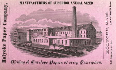
David Butterfield started the Holyoke Paper Mill in 1857 near the junction of the first and second level canals. Its race is still visible from the Main Street side.
1853 – The Hampden Mill was built as a cotton mill. It was first incorporated and the built by the Hadley Falls Company. They ran 10 thousand spindles and employed 300 people.
1854 – Donald Chase McKintosh (1819 to 1902) came from Scotland as a dyer – a boss dyer.
1868 – Donald McKintosh was fired by the Hampden Mills. Then he started MacKintosh Company near the Parsons Paper Mill near the dam. Fire destroyed this small mill. He moved the mill to Northampton. Then he moved back to Holyoke and located at Bigelow Street.
1881 – Name changed to McKintosh and Sons.
1883 – Crystal Spring Aqueduct Company starts in Hampden Mills. Crystal Springs is located near Community Field.
1888 – Hampden Mills went bankrupt. Donald McKintosh bought Hampden Mills. For many years their stock changed – cotton blend, cotton only, and then cotton yarn by 1918.
1943 – Still 300 workers and all seems happy but two years later there is a strike over wages.
1952 – McKintosh Mills is losing money so they move to Clover South Carolina.
family: Donald Chase McKintosh (1819 to 1902)
son – Charles McKintosh (1857 to 1932)
grandson – John McKintosh – banker in Holyoke and Springfield
Sanborn 1915 map shows that the Transcript newspaper was now in the building and in fact had grown to be three buildings wide and thus for the 1949 and 1956 Sanborn maps see the Transcript block
The Prew Building or the J R Smith is a grand Renaissance Revival building. It served as the produce store for J R Smith in its early days. Then John Prew owned it for a while.
The Craft’s Building is still here after these many years. It once held the Star Theater. Also there were many businesses on the ground floor. It is at 141-147 High Street.
The Exchange Block was one of the first buildings in industrial Holyoke. It was most likely made in 1847 or 1848. Roswell Crafts was there with his provision store. It was the building that was there prior to the Crafts. The Exchange burned in 1870 and was replaced.
On the top floor was Exchange Hall. This was a social function area that served many start up churches.
Sanborn map analysis:
Sanborn 1884 map shows that it is three floors and has a dress maker on many floors
The Transcript Building and Block at 172-174 High and 176 High Street housed the newspaper called the Holyoke Transcript and Telegraph. The Holyoke Transcript started in 1854 and became a daily in 1882.
The Dwight family is the main group that ran the Holyoke Transcript for years. See their FAMILY.
The Block started in 1869 in the Italianate style. Below is their 1869 ad.
The Holyoke Telegraph existed on its own from 1915 to 1925. It was located near the Depot Square area. The merger meant more work space was needed so the Transcript Building was made in 1925. This Building might almost be called an Art Deco building.
In 1915 another tenant was the City Directory Office of which I do much of my research.
Before the Transcript Building was made there was another building there that housed the Smith Fish Store. That block at 172 High is unknown at this time. Between that block and the Transcript there was the Bateson Building at 176 and 178 High.
The Caledonia Building has a long history. It is at 185-193 High Street. Architectural Iron Works of New York made the facade. A 1865 book about the firm is at this LINK. A plaque at ground floor on both front corners of the building has their firms name Architectural Iron Works of New York.
The Caledonian Benefit Society purchased this building in 1909. Roswell Crafts had it built in 1874. The top floor is for social function, the ground floor is for retail business, and the middle two floors are for office space. It was built in the Second Empire style. The 4th floor has a skylight and has a staircase to the roof. In the 1900 city directory the hall is being called The Touraine.
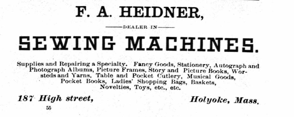
Heidner Merchant was here in 1885 on one of the lower floors.
In 1915 Judd Insurance was here
Sanborn map analysis:
Sanborn 1884 map shows that 1st is stores, 2nd is offices, 3rd is dwellings, and 4th is hall
The Johnson and Johnson Blocks are at 195 High and at 197-201 High Street. Both were made in the Italianate style in 1880. This father and son team sold insurance products. Their agency started in 1866 and must have boomed with the economy since by 1880 they had the nicer structure built. The older and less ornate building might be from their origins. They were still there in 1915 as an insurance and a building.
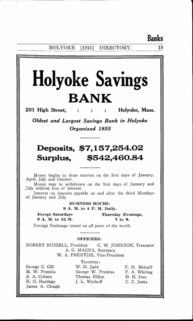
On the 201 High ground floor there was the Holyoke Savings Bank. (from at least 1912 to 1915)
The Wright Building and Block is at three locations along this strip. That is, at 96-100 High, 102-104 High, 106-108 High, and 110-120 High Street. They form a continuous group of structures. Stephen Wright built all four in the 1869 to 1870 era in the Italianate style. When he died 28 June 1888 he was a rich man.
In 1882 to at least 1900 the southernmost block (118 to 120) was being called the Perry’s Building and the 106 to 108 portion was being called the Prew’s Building.