

Daniel Newton in 1873 made the Excelsior Paper Mill.

Advertiser’s Mill or the Taylor Logans Paper Mill

Sanborn map analysis
Sanborn 1915 map now shows it as the Advertiser’s Mill
Sanborn 1949 map – gone
Sanborn 1956 map – gone
Daniel Newton in 1873 made the Excelsior Paper Mill.
Advertiser’s Mill or the Taylor Logans Paper Mill
Sanborn map analysis
Sanborn 1915 map now shows it as the Advertiser’s Mill
Sanborn 1949 map – gone
Sanborn 1956 map – gone

The Wauregan Mill was made by James Newton in 1869.


Associated Factory Mutual Fire Insurance Companies
DIAGRAM from 1914
Sanborn map analysis:


Henry Dickinson started the Connecticut River Paper Mill in 1870 on the Third Level Canal. They are a maker of fine paper with one type being No. 1 High Grade. They were called the Connecticut River Paper Company from the 1870s to the 1890s.

The Purcell Envelope Company which formed in 1894 is a maker of United States stamped envelopes. They in 1896 joined with the Connecticut River Paper Mill.
They are called the Bemis in 1870.

Then they were the Union Paper Mill.
Then a part of Riverside.
Lastly, the United Folding Box Mill.

Sanborn map analysis:
Sanborn 1949 map they are the United Folding Box Mill


The Connecticut River Pulp Mill is a Newton family company. It is from 1876 and lasted to 1886. It was located on the Second Level Canal near the Massasoit. Floors are 1, 2, or 4 high. Work is separated by area. When it closed it moved to the Chemical Mill and to Readsboro Vermont.
Sanborn 1884 map – in 1889 it is no longer there


Daniel Newton made the Albion Paper Mill in 1869. They make book paper. Designed by David Tower. The mill has 12 mill power running 18 1000 pound engines.


Sanborn map analysis:

Warner photograph.
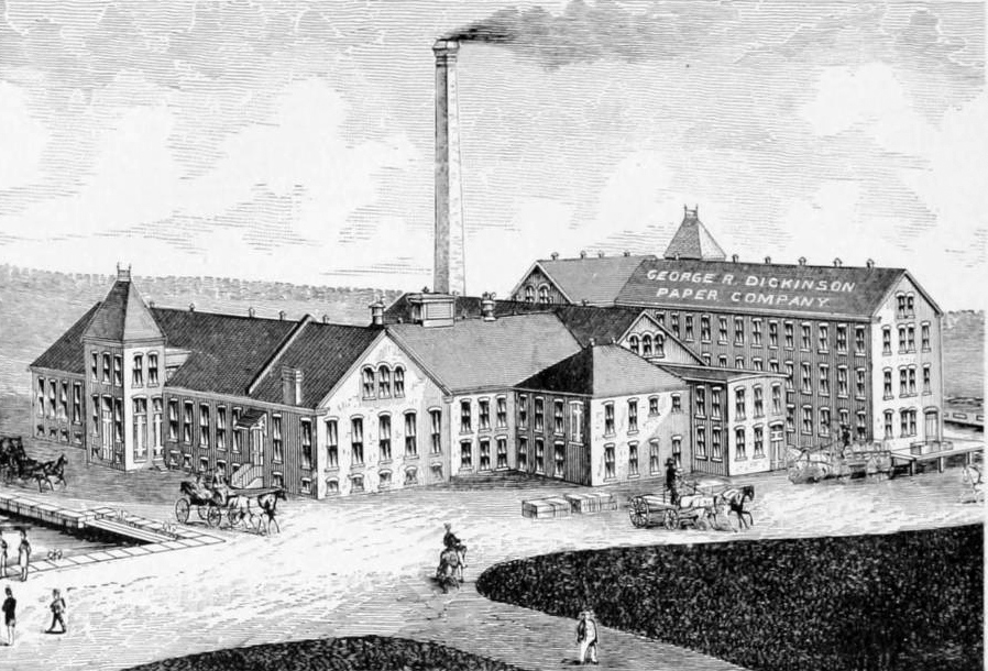
The Dickinson Paper Mill was built in 1882 between the first and second canals. George Dickinson was the owner. The architect was David and Ashley Tower. Note the tower facing the canal. Henry the son of George took over later in life.


Sanborn map analysis:
Sanborn 1949 map – owned by the Holyoke Gas and Electric
Sanborn 1956 map – owned by the Holyoke Gas and Electric

James Newton started the Massachusetts Screw Company in 1873 at the Holyoke Water Power Mill. They made wooden screws and many other products. They would move their operations to along the Second Level Canal.


Sanborn map analysis:
Sanborn 1915 map as the Ford Auger Bit Co
Sanborn 1949 map – weave shed for Farr Alpaca

The Farr Alpaca Mill was started in 1873 by Hubert Farr. It was a Canadian company before that. It is mostly located between the first and second canals. They are a producer of alpaca wool. The alpacas of Peru were the source of the wool fabric. They also made serges.

The company would last in production until 1939.
Inside mill 3 is a company theater which is now called the Winter Palace.
Read Wikipedia about Farr Alpaca.

Sanborn map analysis:
Sanborn 1884 map and map B and Mosher and Bowers Buildings which would later be Farr Alpaca structures – also a storage site
Sanborn 1889 mill 1 map A and map B and mill 2 (not there yet)
Sanborn 1895 map for mill 1 and mill 2 and mill 3 (as HWP buildings)
Sanborn 1915 map (for mill 1) and Sanborn 1915 map (for mill 2) and mill 3
Sanborn 1949 map mill 1 and mill 2 (here is General Electric) and mill 3 (now Hart Top)


The National Blank Book Company is integral to the history of Holyoke. James Towne and his sons grew the company from a small New York City firm in 1843 into the world leader in blank books. In 1881 Edward Towne moved the mill from NYC to Holyoke.

In 1898 they erected their own mill on the Second Level Canal at the juncture with Riverside Station. From 1906 to 1930 it was enlarged 5 different times.


Sanborn map analysis:
Sanborn 1884 1889 and 1895 all show the site is empty but National Blank Book is in the city since they are at the Cabot Street Mill with other small developing firms.
Sanborn 1949 map plus there is a site 2 buildings away to the north


Thomas Holley made the American Pad Company in 1884 in Holyoke. They started small as a processer of waster paper.

Sanborn map analysis:
Sanborn 1884 map – near start of Main Street
Sanborn 1889 map – Whiting Street Building on Main Street
Sanborn 1895 map – Whiting Street Building on Main Street
Sanborn 1915 map – NE corner of Appleton and Winter Streets
Sanborn 1949 map – NE corner of Appleton and Winter Streets
Sanborn 1956 map – NE corner of Appleton and Winter Streets